
Mentioned in the Dancing Hare song ‘Coldrum Stones’ which I composed in 2014 (on the forst Dancing Hare album), this is the first in little set of articles focusing on my personal journies tothe Medway Megaliths, which extend from Addington neolithic sites up to the North Downs. The name Kit’s Coty is derived from old English “Tomb in the forest”.
Firstly to Little Kit’s Coty, under one mile from Kit’s Coty (not the same site, two seperate ones).
These stones are rather elusive to locate, as they are inset from a generous hedgerow,  with the brown background ancient monument site often overgrown. I wouldn’t recommend parking directly by them, as the road is quite fast and busy, with enough curves and small blind corners.
My preference was to park in Aylesford village centre (very well signposted) and there are two ‘free for 23 hours’ car parks on your left and right, just after going over the railway level crossing and curving around to go over the river Medway. The car parks are just before the sharp left hand turn that invites driving through the main village. Parking is recommended before here, as it is well worth a visit to the neighbouring priory and that is worthy of a separate visit too, along the narrow streets of the village centre.
Walking through the narrow pavements you will then find a turn rightward for the Rochester Road and on your left, you will find wonderful old buildings connected to the priory and the path of a stream and then the pathways give way as the road becomes more narrow as the rise of the North Downs becomes apparent in full view. There are some that use the road Pratling Street as a marker for getting close, but ignore the first turning on your right, as it’s a horseshoe road and its second entrance, closer to the Countless Stones, is much further up.
Taking care to swap sides on the road to keep your self in view of oncoming traffic, there is a bridle path on private land that the owner has kindly given permission for walking in parallel for about just over a third of the distance in the gentle incline. When this path runs out, it’s back to the road and listening out for oncoming traffic and just checking you are safe when you can hear traffic that is going to pass in both directions at your current walking point. Just take care to swap over some of the little blind spots, where it is better to not face oncoming traffic. There are also a few recesses in standing just inside a couple of yards of the beginning of private drives to farm land or houses.
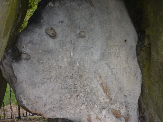
The first stone you will see is a mysterious special one, in that it has been agreed by some historians to have been located from one of the lost barrows in the cluster of the Medway Megaliths, due to ploughing and lack of care for their antiquity. On the left hand side, you will see this single stone, at Tottington Farm entrance, which appears to have been relocated, possibly from the private land cluster of small fallen stones, known as the Coffin Stones.
Other stones lost or destroyed around here that were recorded by antiquarians in previous centuries include an accumulation of pointers towards various accounts of more stones than we sadly do not get to see today. Work is still ongoing and the Kent Archaeology group have featured some of the potential lost stones in this pdf article: Kent Archaeology-lost stones and possible sites.

After viewing this ancient stone, the second entrance to Pratling Street is viewed on your right. At this point you can see the traffic line that is part of the major road climbing Bluebell Hill.

The enterance to Little Kit’s Coty / Countless stones is on your right, just before you reach the pylon wires and it’s definitely before the pylon support, in the smallest of openings. If you were to drive up and down the road, it would be easy to miss this enterance. The brown sign is nestled in sometimes overgrown hedges.

The small opening leads you to the stones after just a few footsteps.

Why the Countless stones? In this fallen chamber, the stones have overlapped one another and of various different sizes and depending on how you count them down to the smallest, it is easy to see how this could be a point of discussion over many decades.


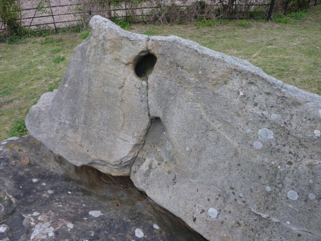


It is unfortunate that we have a pylon wire going overhead close by, which is surprising that it couldn’t have been placed in a slightly different route, not so close to this ancient monument. The stones have been dated to about 2500-3000 B.C. and we are fortunate that they have not suffered the same fate (as famously with Avebury and it’s lost stones for building material) of being ploughed away or used for roads and/or building repair.
Close by, it has been recorded the removal and loss of a couple of recorded tombs until recent times, which were Smythe’s monument recorded in 1823 (recovered urn and similar but removed cluster to Little Kit’s Coty) , the destruction of an Aylesford Megalith and the Lower White Horse stone, which cannot be checked as it’s site is now under the dual carriageway and completely lost.
There’s more information on some of the lost barrows and ancient springs at the superb and extensive Megalithic Portal , which includes ancient springs and many other ancient markers.
From this point onwards, it’s then easy to walk from Little Kit’s Coty to the more complete dolmen site, where the more complete orthostats and capstone have remained intact and in the more complete ‘H’ shape.
As the Rochester road becomes a larger road and becomes part of the T junction at the top, you will see the Pilgrims Way road to your left and the Rochester then carries on rightward.

Just crossed safely over the busy junction look back down towards the direction I have walked up, I’m standing right at the start of the climbing path to Kits Koty.

Safely cross over taking account of blind corners on the turn (keep safe) and then crossover completely in the north direction. There will be a wooden sign for the North Downs Way walks, ignore the left posted Westward one and enter the north path which has tree arches covering the path in a steep but mostly cleared walking track.


I did have to walk around a couple of fallen trees and just walk around the field perimeter until back on the path, but these may be cleared sometime after writing this, as they are well frequented by many ramblers and enthusiasts to the general Bluebell Hill area that Kit’s Coty is part of.
The path will take you up steeply for about 10 minutes and then there will be the smallest of clearings, keep looking to your left as the path loses it’s steeper gradient.


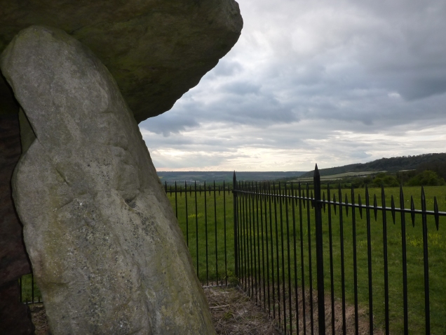
A few footsteps and marked by a sign and you are there. The first thing you will notice is that the burial chamber was one of the first ancient sites to be protected and railings are around it. Although this may be slightly annoying for some, it has protected the stones. The view is breathtaking and you can see why this chamber was constructed here. You can view a whole large section of the Medway valley and the North Downs continuation and it’s exposed chalk. There’s plentiful clusters of ancient flint stone and what a view it must have been to the Neolithic ancestors, when the Medway valley into the Kent and Sussex Weald was still heavily forested.


The whole area was noted for the first signs of early farming, with excavations in this area of grain pits and various fire related smelting and early pottery. It is no surprise that such a viewpoint would be home to early settlements and the reverie of it produce these ancient places of final rest of the ancestors. The river Medway and many ancient wells and springs are noted, perfect for life on and descending into he valley from the downs Kit’s Coty resides on.
I see the whole area with the same fascination of the wider settlements beyond a key set of stones (such as how Avebury is in relation to West Kennett long barrow and Silbury Hill and the recent discovery of the super henge, in addition to Woodhenge, Stonehenge and the vast area of barrows and springs).


It is sad that in the passing of the centuries, that we have lost some key Dolmens and standing stones of various kinds, including potential avenue markers to ploughing and road developments. To many, over the years, they have been a ‘pile of rocks’ and often, when fallen over into the soil, have then been seen as a hinderance to more modern ploughing methods, to be removed, resited or broken up for building stone or road repairs in earlier centuries.
There is a reference to some fallen stones now lost further down the valley where the Medway reaches Tonbridge and it’s interesting to note that in the neighboring Edenbridge, some of the earliest production of iron smelting in the U.K. has been found in various excavations. The Medway emerges out into the Thames estuary and so it is easy to see how this part of the county of Kent played it’s part in our earliest history and our pagan ancestors.
In the 5th century, the Battle of Aylesford was recorded where legend has it that Horsa (brother Hengist) was either laid to rest, buried or banner laid upon the nearby White Horse stone.
Myths, ancestors, legends and sacred places, the Medway has some remaining jewels in our early history. I have shown you my walk, which is in no way definitive of how you wish to approach your journey to the two Kit’s Coty sites. I hope this overview is of interest from afar, or if you also get the opportunity to get to visit these stones, without missing them, compared to more obvious sacred sites such as Stonehenge and Avebury.
The next article (I’ll link these pages together so they jump from one site to another on this blog) will be a personal view of the Coldrum Stones and Addington Longbarrow in the coming weeks.

Matt Lyons with Calsita the Chihuahua
April 2017
